Belleview, Florida — Marion County Fire Rescue crews Monday night were fighting a massive fire at the Market of Marion flea market, located at 12888 Southeast U.S. 441.
MCFR Public Information Officer James P. Lucas said that 17 units and 53 firefighters responded to the fire.
According to Lucas, approximately 30,000 gallons of water were used to extinguish the fire.
The fire damaged building C. Approximately 9600 square feet of the building was destroyed.
The owner estimated property loss at approximately $300k.
The State Fire Marshal said it is too early in the investigation to determine how the fire started.
Firefighters arrived on the scene at 7:12 p.m. and had the blaze under control by 8:19 p.m.
The Florida Fish and Wildlife Conservation Commission (FWC) is reminding people to help prevent conflicts with bears by securing garbage and other items that might attract these animals.
In the fall, Florida black bears begin preparing for the winter by consuming extra calories to pack on fat. During this time, they will eat anything that’s convenient and feeding on garbage provides more calories and less effort than foraging in the woods.
By securing your trash and other food attractants, you can help keep both people and bears safe.
To keep bears wild and away from your home, follow these simple tips:
Secure household garbage in a sturdy shed garage or a wildlife-resistant container.
Put household garbage out on the morning of pickup rather than the night before.
Secure commercial garbage in bear-resistant dumpsters.
Protect gardens, bee yards, compost and livestock with electric fencing.
Encourage your homeowner’s association or local government to institute ordinances to require trash be secured from bears.
Feed pets indoors or bring the dishes in after feeding.
Clean grills and store them in a secure place.
Pick ripe fruit from trees and remove fallen fruit from the ground.
Remove wildlife and bird feeders or make them bear-resistant. See the new “Bears and Bird Feeders” video in the “Brochures and Videos” section at com/Bear.
It is illegal in Florida to intentionally feed bears or leave out food or garbage that will attract bears and cause human-bear conflicts. If you see or suspect someone is feeding or attracting bears, please call the FWC’s Wildlife Alert Hotline at 888-404-FWCC (3922).
You also can help people and bears stay safe by remembering to watch for bears while driving.
This time of year, bears are traveling across more roads in search of food, which results in more vehicle-bear collisions.
The FWC advises drivers to be aware of their surroundings as they drive in bear country, especially around dusk and dawn, and when there is a forest on both sides of the road.
The FWC works with Florida Department of Transportation to post bear crossing signs in areas that receive particularly high levels of vehicle-bear collisions and plan locations for wildlife underpasses to allow bears and other animals to cross safely under roadways.
Motorists traveling in Marion County will experience temporary lane closures in the northernmost westbound lane of County Road 42, between the intersections of Southeast 73rd Avenue and Southeast 90th Court.
The closures will take place on weekdays from September 9 through 27, 2019.
Sumter Electric Cooperative, Inc. will be conducting maintenance on the splice boxes located in the county right-of-way.
Crews will place barricades, signage, and have flaggers to direct traffic through detours and the work zone while work is being performed.
Please note that construction schedules may change due to weather or other circumstances, and if this happens, the closure may be rescheduled.
Officials ask that all drivers remember to yield to roadside workers and obey posted speed limits. Speeding fines are doubled in a construction zone.
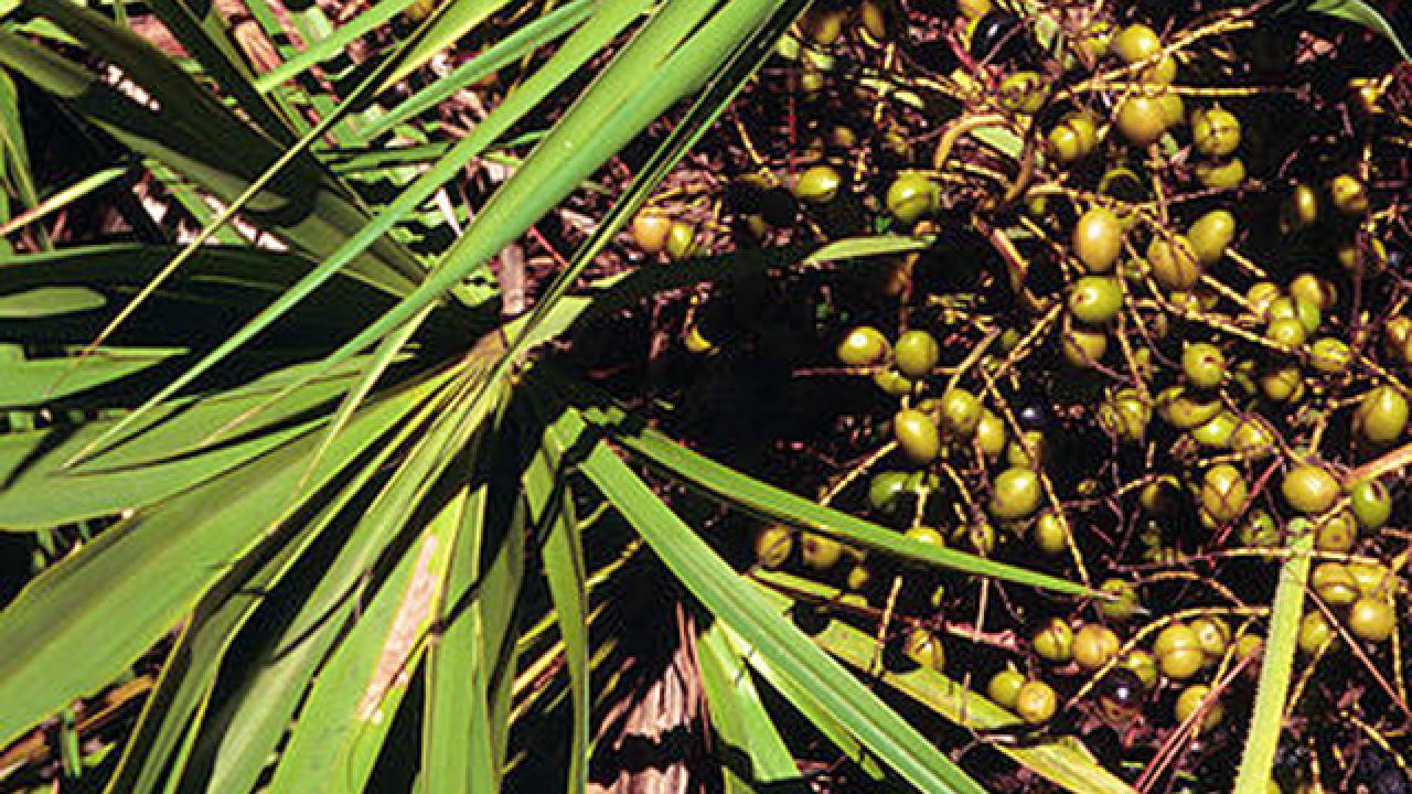
Two people were arrested for allegedly harvesting saw palmetto berries.
According to the Florida Department of Agriculture and Consumer Services, as of last July, a permit is required to harvest the berries in Florida.
The two were harvesting the berries after midnight on Friday in the vicinity of the Baseline Trailhead Park when they were seen as the MCSO helicopter happened to be in the area.
Those on the helicopter then radioed to a deputy who tracked down the man and woman, later identified as Elizabeth Merson, 32, and Frederick Allen Graff, 45.
The two were booked into the Marion County jail on misdemeanor charges.
What are the new requirements for a contract harvester of palmetto berries on public or private land?
The contract harvester must possess written permission from the landowner or the legal representative
prior to harvest
The contract harvester must also possess a Native Plant Harvesting Permit from the Department prior
to harvest. The permit application must be submitted fourteen (14) days prior to the intended date of
harvest.
What are the new requirements for any person transporting for sale, selling, or offering for sale saw palmetto berries?
A person transporting for sale, selling, or offering for sale saw palmetto berries, which is harvested from the person’s own property, must possess a Native Plant Harvesting Permit from the Department.
The permit application must be submitted fourteen (14) days prior to the intended date of
harvest.
What enforcement action can be taken if these requirements are not followed?
If found by law enforcement officials to not meet the requirements above, the harvester or person
transporting for sale, selling, or offering for sale saw palmetto berries may be charged with a
misdemeanor. The illegally harvested berries will be confiscated and returned to the owner. If the owner cannot be located, the berries will be destroyed.
According to officials, saw palmetto is a supplement made from the fruit of the Serenoa repens tree, which is commercially exploited.
It’s often used to treat enlarged prostate, improve urinary function, and enhance hair growth. Some also use the supplement to boost libido and fertility and reduce inflammation. Additionally, saw palmetto is claimed to have anti-cancer effects.
Allegedly, Native Americans have long used the berry for its nutritional, sedative, diuretic, aphrodisiac, and cough-reducing properties.
All Marion County Public Schools reopen Thursday and Friday and return to normal schedules.
Shelters are closing Wednesday.
Initially, due to Hurricane Dorian, the Marion County School Board announced that all schools would be closed Tuesday-Friday.
Marion County Public Schools Public Relations Director, Kevin Christian, confirmed this information to Ocala Post.
In an email, school board officials wrote, “With Marion County Emergency Management closing shelters, we are pleased to reopen our schools Thursday and Friday. We realize some families may be out of town based on previous announcements, and we encourage those families to remain safe as they journey home.”
Message: NOAA-NWS-ALERTS-FL125D0FA99394.TropicalStormWarning.125D0FAAD18CFL
.JAXTCVJAX.3889fbd22ddb53ad5e8b246f47ff038e from w-nws.webmaster@noaa.gov
Sent: 23:01 EDT on 09-03-2019
Effective: 23:01 EDT on 09-03-2019
Expires: until further notice
[The above portion of this alert was intentionally included by Ocala Post]
As of 23:01 (11:01 p.m.) a tropical storm warning remained in effect for the following areas:
Lynne
Moss Bluff
The National Oceanic and Atmospheric Administration (NOAA) and the National Weather Service (NWS) out of Jacksonville, stated that the winds have decreased from previous assessments. The latest local forecast shows peak winds at 10 to 20 mph, with gusts to 45 mph.
At this time, the sustained wind should remain less than tropical storm force with gusty conditions.
The NOAA and NWS reported, “Little to no preparations [are] needed to guard against tropical winds at this time. Ensure emergency readiness should the forecast change.”
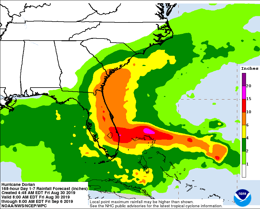
Latest rain forecast
Peak Rainfall Amounts will be an additional 1-3 inches, with locally higher amounts. There is a potential for localized flooding, which has remained a steady threat. Emergency plans should include the potential for localized flooding from heavy rain. Consider protective actions if you are in an area vulnerable to flooding. Heed any flood watches and warnings.
Rivers and tributaries may quickly rise with swifter currents. Small streams, creeks, canals, and ditches may become swollen and overflow in spots. Floodwaters can enter a few structures, especially in usually vulnerable spots. A few places where rapid ponding of water occurs at underpasses, low-lying spots, and poor drainage areas. Several storm drains and retention ponds become near-full and begin to overflow. Some brief road and bridge closures.
Local tornado warning/watch
The situation is unfavorable for tornadoes as tornadoes are not expected. Showers and thunderstorms
with gusty winds may still occur. Watch your local weather, or listen to your NOAA/NWS approved weather radio for changes in the forecast.
When reading the graphics, pay close attention to the color codings for the area over Marion County.
Stay tuned to your local weather channel for changes in the forecast.
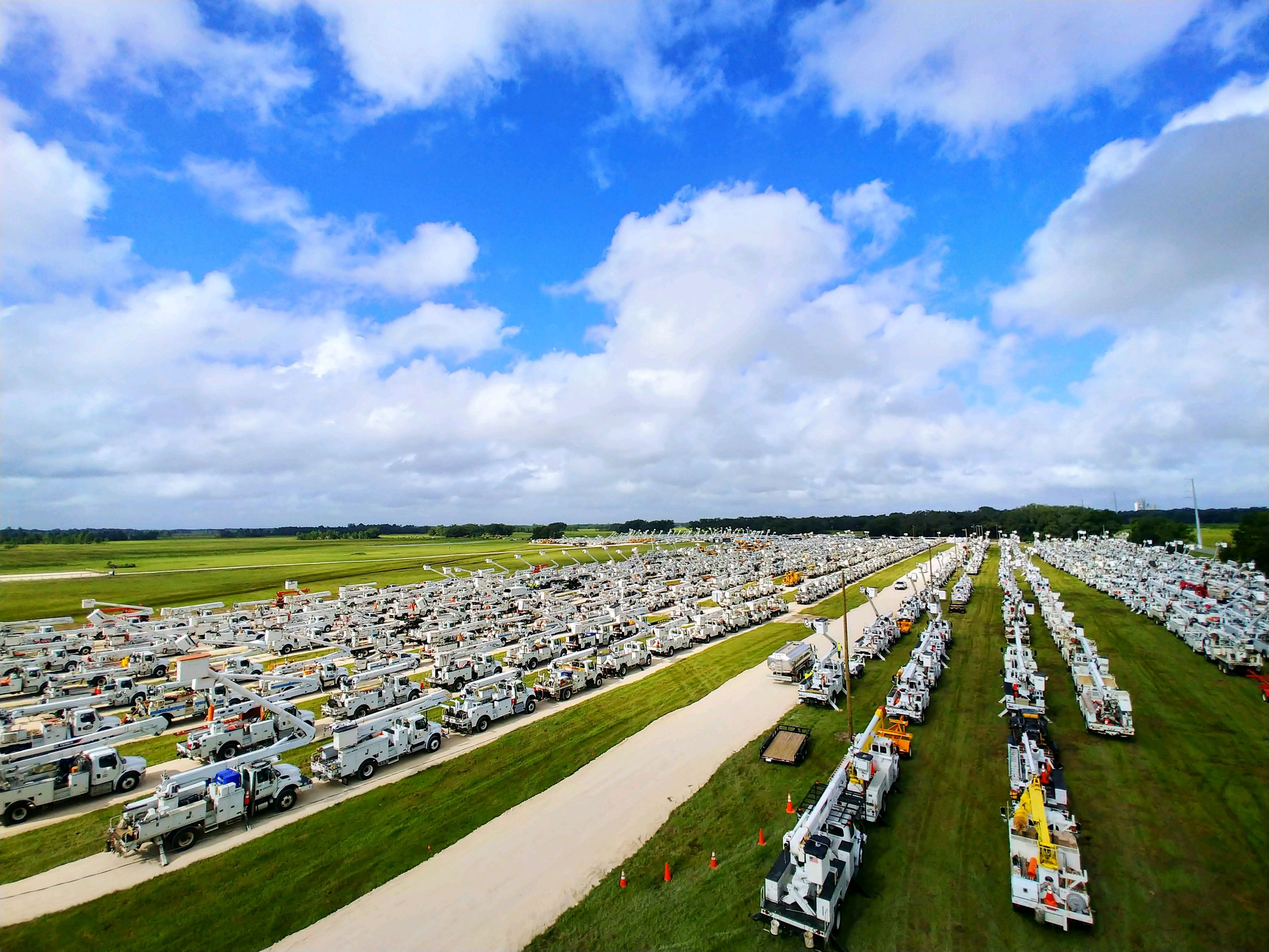
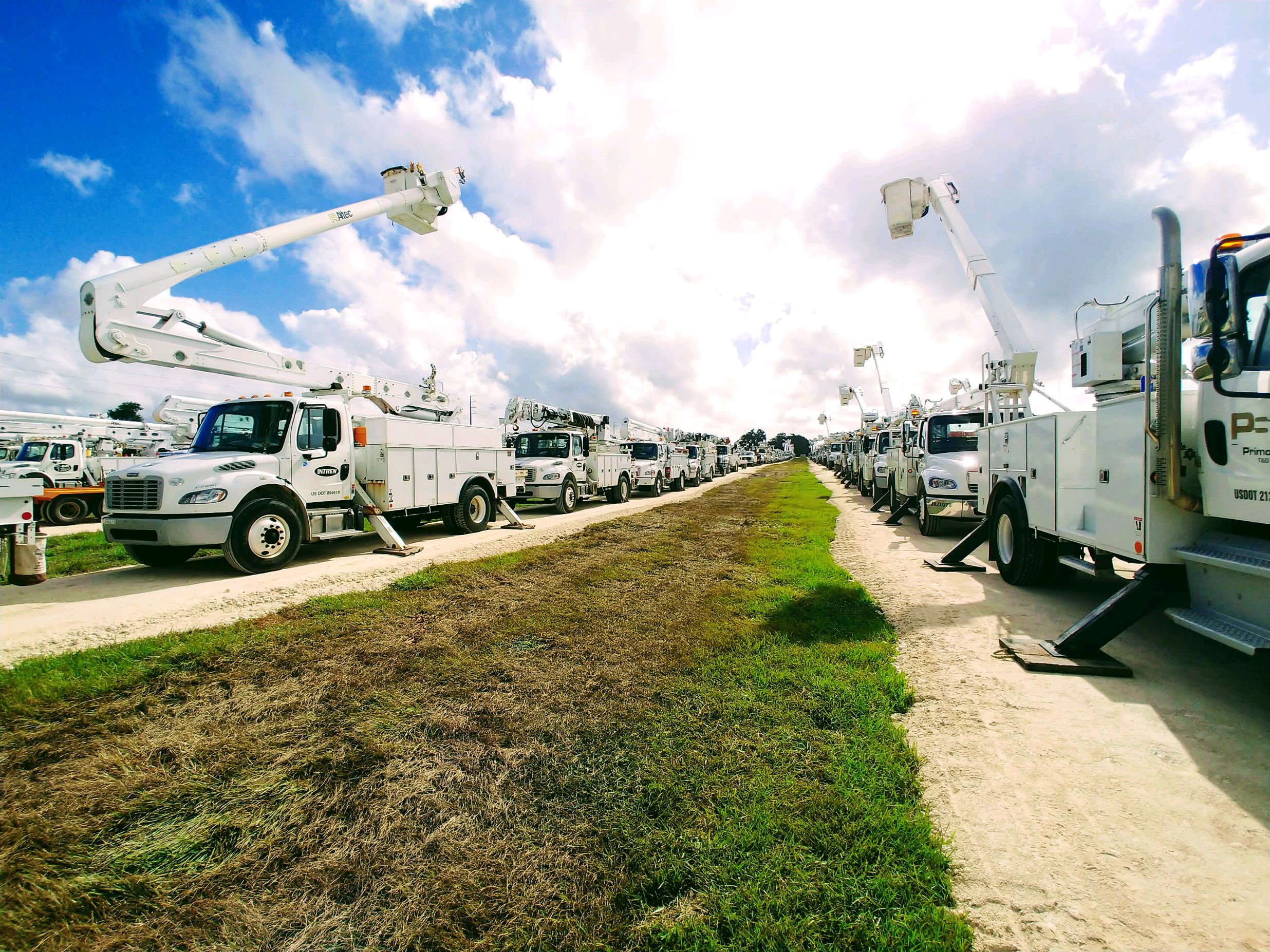
It really is a sight to see. Video is one thing, but seeing the site in person is something even more spectacular.
It is an even more spectacular view from 50 feet in the air.
Article continued below
More than 5,000 workers and 7,000 individual pieces of equipment are ready to roll to the areas in Florida that could possibly be hit by Hurricane Dorian.
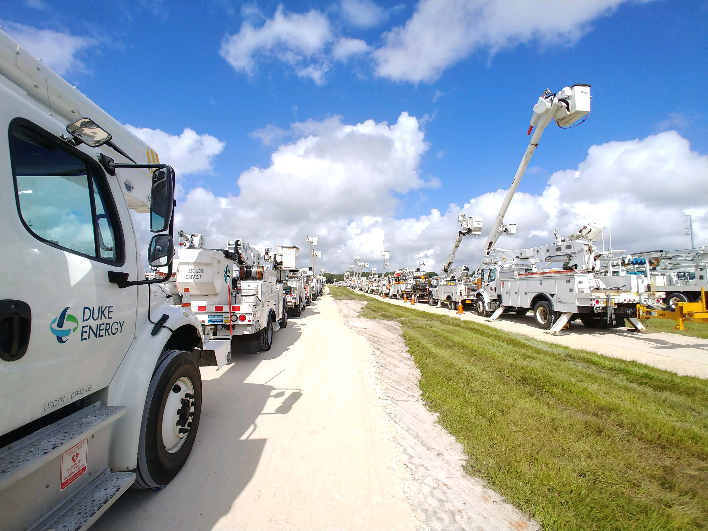
“The 135-acre muster location in The Villages of Sumter County was a grass pasture just four days ago. Now, this is a central hub for line crews from across the country to park their trucks, get their trucks inspected by a mechanic and refuel before heading to nearby hotels to get some rest,” Duke Energy Communications Manager, Heather Danenhower, said.
Danenhower said the muster location in The Villages of Sumter location is ideal because it is centrally located with easy access to the Florida Turnpike and Interstate-75. She said the property is also versatile and has enough room for them to expand their operation if needed.
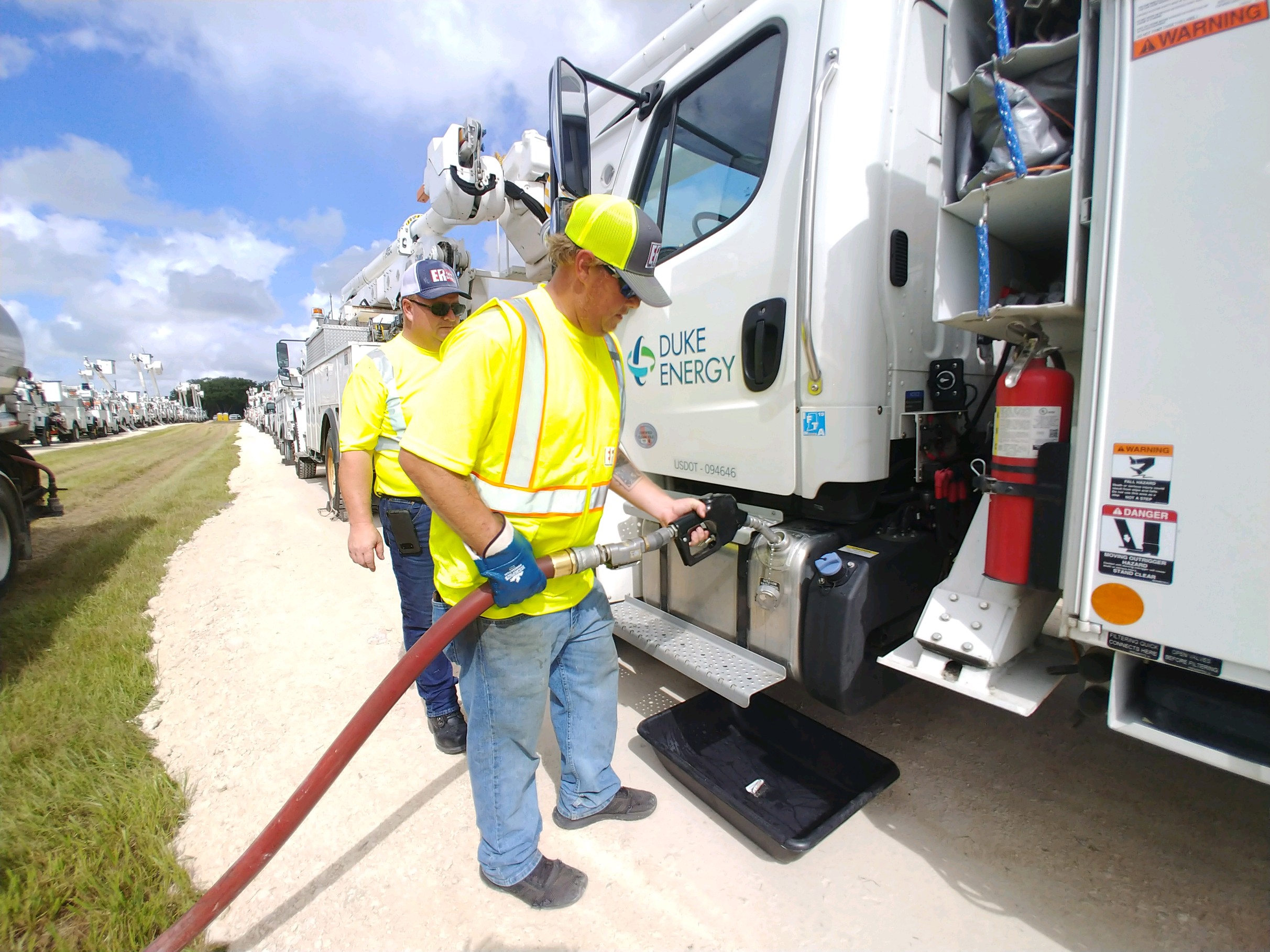
On the property, crew members refuel line and tree-trimming trucks and get their trucks inspected to ensure maximum safety.
Article continued below
Crew members refuel line and tree-trimming trucks
According to the U.S Department of Labor and Statistics, being a lineman is in the top 10 for most dangerous jobs.
Trish Moss, said, “This is amazing. In my opinion, besides our military, these are true heroes.”
“Thank God for these men who do this every day, especially in the aftermath of a storm. It is horrible to be without power for any amount of time, or for lift stations to be down. And if you are elderly or have young children, it is even harder. We thank you,” Tanya Ridge said.
Article continued below
Even if Dorian skirts Florida, Danenhower says it is still a dangerous category 4 hurricane that could bring storm surge, flash flooding, and strong winds.
Duke Energy does expect widespread and extended outages in many of the counties Duke serves.
In addition to Duke trucks, there are other service trucks from 30 different states. Including, Alabama, Illinois, Indiana, Iowa, Kentucky. Minnesota, Mississippi, Missouri, Ohio, Tennessee, Texas, and more.
Danenhower said, “We are coming together for one purpose…to safely and quickly restore power to our customers so they can return to normalcy once Dorianpasses.”
Article continued below
“Systemwide, Duke Energy has deployed about 6,500 crews to help us restore power once it is safe to do so, including 800 line crews from Duke Energy’s Midwest fleet. The Sumter County muster location is one of three strategic locations we have set up in Florida – and the largest. The other two locations are in Pinellas and Polk counties,” Danenhower said.
On Monday, crews were securing the property until it is time to hit the road. For now, they will head to local hotels where they will rest until Hurricane Dorian passes and they are dispatched.
Fort Smith, Arkansas — Attention continues to grow surrounding the Aug. 24 drowning of Debra Stevens, a Fort Smith newspaper delivery woman, who was battered by a 911 dispatcher right before she drowned.
Debra was delivering papers at 6 a.m. in the morning when it was pitch black. Those who live in the area told authorities that it was “very difficult” to see that the rising water had engulfed the roadway.
Article continued below
First responders, said, “It was very difficult to see the water where her SUV was located. The water blended in with the darkness of the morning.”
In the 911 call, which was more than 25 minutes long, you can hear the terror in Debra’s voice, but the last words that were spoken to her in her time of need and fear were the unkind words of the dispatcher.
Article continued below
Interim Police Chief Danny Baker attempted to conceal the 911 call, as well as the dispatcher’s name, however, he was ordered to turn over the information to the media following push from Debra’s family and attorney.
911 Dispatcher Donna Reneau
The 911 dispatcher, Donna Reneau, was working her last day after having submitted her resignation prior to taking her last 911 call, a 911 call that family members say cost an innocent woman her life.
“Chief Baker is just as uncaring as the dispatcher, no wonder she worked there. It is the mentality of that department, clearly,” family members said.
Chief Baker said, “The manner that she spoke during this conversation would have probably been addressed, but it would have been more a rudeness quality type service complaint. I don’t think it would have risen to the level of terminating someone.”
“This is a huge problem. The mentality that law enforcement agencies can do no wrong has to stop. Listen to that 911 call, it is the most gut-wrenching horrendous thing you will listen to. At the end of the 911 call, you can hear [Debra] taking in air, gurgling water before she died. To think that the dispatcher would have gotten a slap on the wrist,” attorneys said.
Article continued below
The Fort Smith Police department, as well as Donna, has received numerous death threats.
The police department says that they have received death threats from all over the country and across all platforms, including mail.
Aric Mitchell, with the Fort Smith Police Department, said they are not taking the threats seriously at this time.
The public is calling for Police Chief Baker to resign.
Ocala Post obtained the 911 call in its entirety. However, due to the disturbing nature of the call, especially at the end, and out of respect for the family, the decision was made not to publish it in its entirety.
Due to Hurricane Dorian, the Marion County School Board announced that ALL schools will be closed Tuesday-Friday.
Marion County Public Schools Public Relations Director, Kevin Christian, confirmed this information to Ocala Post at approximately 2 p.m.
In a press release, officials wrote, “This closure allows time for our students, families, and employees to better prepare for the storm *AND* provides set-up time for the schools that may serve as shelters.”
Twelve-month employees should report to work as usual unless safety concerns keep them at home. In these cases, employees can request time off from their immediate supervisor.
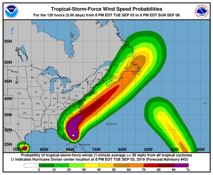
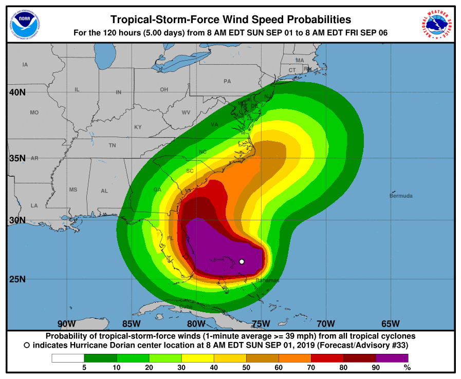
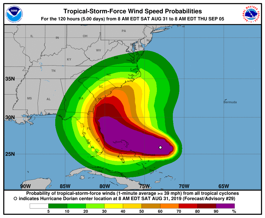
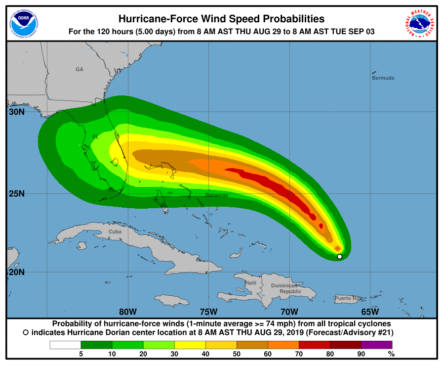
This graphic from the NOAA and NWS shows the tropical-force wind speed probabilities.
The following are important changes in weather watches and warnings. This information comes directly from the National Weather Service (NWS).
Dorian has weakened slightly but remains a very dangerous category 4 hurricane.
If you have family or friends in any of the areas who do not have access to the news, you should alert them.
Don’t panic, not all of the information pertains to Marion County. However, many readers have elderly family members in the listed areas, and at the request of our readers, the decision was made to include that information.
Changes to watches and warning:
– A Storm Surge Watch and Hurricane Watch have been issued for Coastal Camden and Coastal Glynn
– A Storm Surge Watch has been issued for Inland Glynn- A Storm Surge Watch and Hurricane Watch are in effect for Coastal Camden, Coastal Duval, Coastal Flagler, Coastal Glynn,
Coastal Nassau, and Coastal St. Johns
– A Hurricane Watch is in effect for Inland Flagler and Inland St. Johns
– A Storm Surge Watch is in effect for Inland Glynn
– A Tropical Storm Watch is in effect for Clay, Eastern Marion,
Inland Duval, Inland Nassau, and Putnam
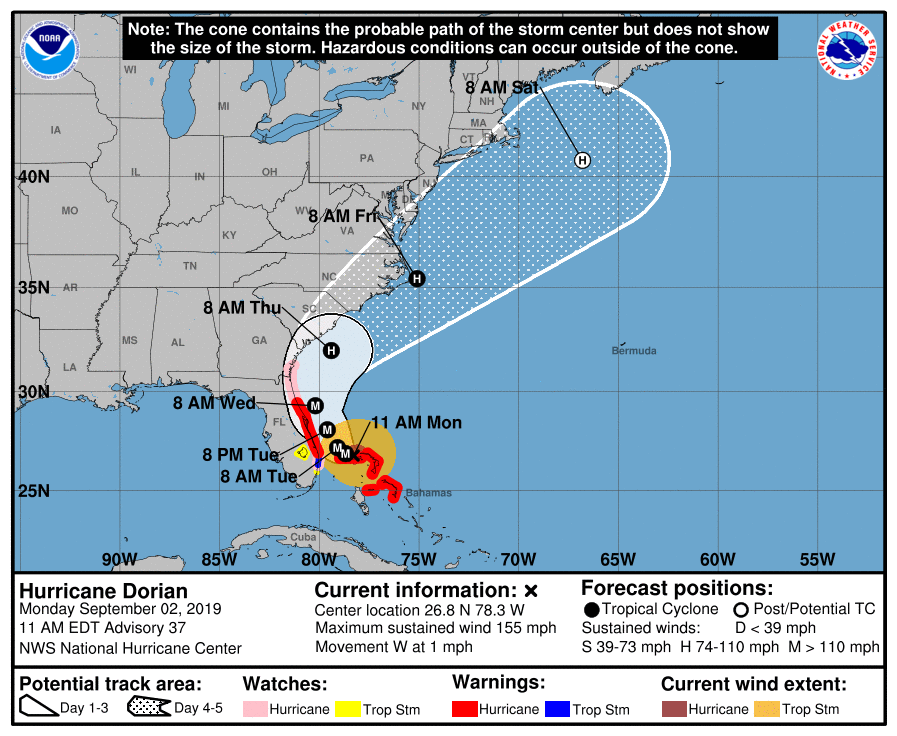
Storm information:
– About 310 miles southeast of Jacksonville FL
– 26.8N 78.3W
– Storm Intensity 155 mph
– Movement West or 280 degrees at 1 mph
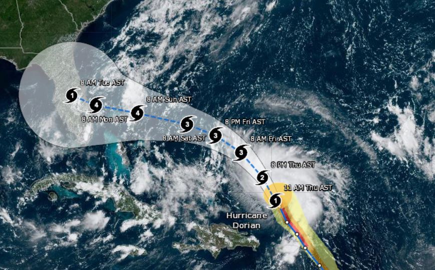
Hurricane Dorian is a powerful and extremely dangerous Category 4 hurricane with peak winds near 155 mph.
Dorian`s forward progress has slowed as it continues to move west through the northwestern Bahamas.
By Tuesday, powerful Dorian is forecast to turn northwest on its way towards the Florida coast. As Dorian slowly approaches, it is forecast to turn north-northwest and parallel the coastline Tuesday into Wednesday.
“At this time, the exact track remains uncertain, and small changes in the forecast, the track could have large influences on the threat of damaging winds and life-threatening storm surge,” NWS said in a statement.
Regardless, as the storm slowly draws closer, the risk has increased with the latest forecast. Should Dorian approach even closer, it would produce more serious impacts to coastal areas.
Large battering waves and higher than normal tides will add to the destructive potential, along with beach erosion.
Heavy rainfall is forecast over eastern parts of northeast Florida and coastal southeast Georgia and with total accumulations of 4 to 8 inches…with maximum isolated rainfall amounts to 10 inches along
the east coast. Flash flooding is possible, especially in urban and poorly drained areas.
Potential impacts
Surges:
Prepare for life-threatening surge having possible extensive impacts across the beaches of coastal northeast Florida and southeast Georgia. As well as the mouth of the St Johns River. Potential impacts in this area include:
– Large areas of deep inundation with storm surge flooding accentuated by battering waves. Structural damage to buildings, with several washing away. Damage compounded by floating debris. Locations may be uninhabitable for an extended period.
– Large sections of near-shore escape routes and secondary roads washed out or severely flooded. Flood control systems and barriers may become stressed.
– Severe beach erosion with significant dune loss.
– Major damage to marinas, docks, boardwalks, and piers. Many small craft has broken away from moorings, especially in unprotected anchorages with some lifted onshore and stranded.
Wind:
Prepare for life-threatening wind having possible extensive impacts across coastal sections of northeast Florida and southeast Georgia.
Potential impacts in this area include:
– Considerable roof damage to sturdy buildings, with some having window, door, and garage door failures leading to structural damage. Mobile homes severely damaged, with some destroyed. Damage accentuated by airborne projectiles. Locations may be uninhabitable for weeks.
– Many large trees snapped or uprooted along with fences and roadway signs blown over.
– Some roads impassable from large debris, and more within urban or heavily wooded places. Several bridges, causeways, and access routes impassable.
– Large areas with power and communications outages.
Also, prepare for dangerous wind having possible limited to significant impacts across inland Nassau, inland Duval, Clay, Putnam, and eastern Marion Counties.
Flooding:
Prepare for dangerous rainfall flooding having possible significant impacts across coastal northeast Florida and southeast Georgia.
Potential impacts include:
– Moderate rainfall flooding may prompt several evacuations and rescues.
– Rivers and tributaries may quickly become swollen with swifter currents and overspill their banks in a few places, especially in usually vulnerable spots. Small streams, creeks, canals, and ditches overflow.
– Floodwaters can enter some structures or weaken foundations. Several places may experience expanded areas of rapid inundation at underpasses, low-lying spots, and poor drainage areas. Some streets and parking lots take on moving water as storm drains and retention ponds overflow. Driving conditions become hazardous. Some road and bridge closures.
Preparedness
Evacuations:
Listen to local official for recommended preparedness actions, including possible evacuation. If ordered to evacuate, do so immediately.
For those not under evacuation orders, assess the risk from wind, falling trees, and flooding at your location. If you decide to move, relocate to a safer location nearby. If you do not relocate, help keep
roadways open for those under evacuation orders. If evacuating, leave with a destination in mind and allow extra time to get there. Take your emergency supplies kit. Gas up your vehicle ahead of time.
Let others know where you are going prior to departure.
Secure loose items and pets in the car, and avoid distracted driving.
If evacuating, follow designated evacuation routes. Seek traffic information on roadway signs, the radio, and from official sources.
Now is the time to check your emergency plan and emergency supplies kit and take necessary actions to protect your family and secure your home or business.
When making safety and preparedness decisions, do not focus on the exact forecast track since hazards such as flooding rain, damaging wind gusts, storm surge, and tornadoes extend well away from the
center of the storm.
If in a place that is vulnerable to high wind, such as near large trees, a manufactured home, upper floors of a high-rise building, or on a boat, plan to move to safe shelter. If you live in a place particularly vulnerable to flooding, such as near the ocean or a large inland lake, in a low-lying or poor
drainage area, in a valley, or near an already swollen river, plan to move to safe shelter on higher ground.
Always heed the advice of local officials and comply with orders that are issued. Do not needlessly jeopardize your life or the lives of others.
When securing your property, outside preparations should be concluded as soon as possible before conditions deteriorate. The onset of strong gusty winds or flooding can cause certain preparedness
activities to become unsafe.
Be sure to let friends and family members know of your intentions for weathering the storm and your whereabouts. Have someone located away from the threatened area serve as your point of contact. Share vital contact information with others. Keep cell phones handy and charged.
Check on those who may not be fully aware of the situation or who are unable to make personal preparations.
The next local statement will be issued by the National Weather Service in Jacksonville FL around 6 PM, or sooner if conditions warrant.
Hurricane Dorian made its first landfall on Elbow Cay in the Bahamas, at 12:45 p.m. Sunday, with maximum sustained winds of 185 mph and gusts over 220 mph. A second landfall occurred shortly thereafter over Marsh Harbour, on the island of Great Abaco, with the same intensity.
While this powerful, historic hurricane still spins, unsung heroes are preparing to deploy, and no, we are not talking about our military.
Dozens of linesman have gathered in Wildwood, Florida, and are prepared to leave their families and put themselves in danger if Dorian hits any part of the Florida coast, Georgia, or the Carolinas.
According to the Department of U.S Labor and Statistics, being a linesman is in the top 10 for most dangerous jobs.
Dalton Waldroup shared the incredible video and tagged Josh Dooley, Daniel Groves, and Corey Brown.
Trish Moss, wrote, “This is amazing. In my opinion, besides our military, these are true heroes.”
“Thank God for these men who do this every day, especially in the aftermath of a storm. It is horrible to be without power for any amount of time, or for list stations to be down. And if you are elderly or have young children, it is even harder. We thank you,” Tanya Ridge wrote.
The National Hurricane Center said Dorian is the strongest hurricane in modern times to ever hit the northwestern Bahamas and it was tied for the strongest Atlantic hurricane landfall on record with the 1935 Labor Day hurricane.
Thank you, Mr. Waldroup, for sharing this video with us.
Due to Hurricane Dorian, the Marion County School Board announced that ALL schools will be closed on Tuesday.
In a press release, officials wrote, “This closure allows time for our students, families, and employees to better prepare for the storm *AND* provides set-up time for the schools that may serve as shelters.”
Twelve-month employees should report to work as usual unless safety concerns keep them at home. In these cases, employees can request time off from their immediate supervisor.
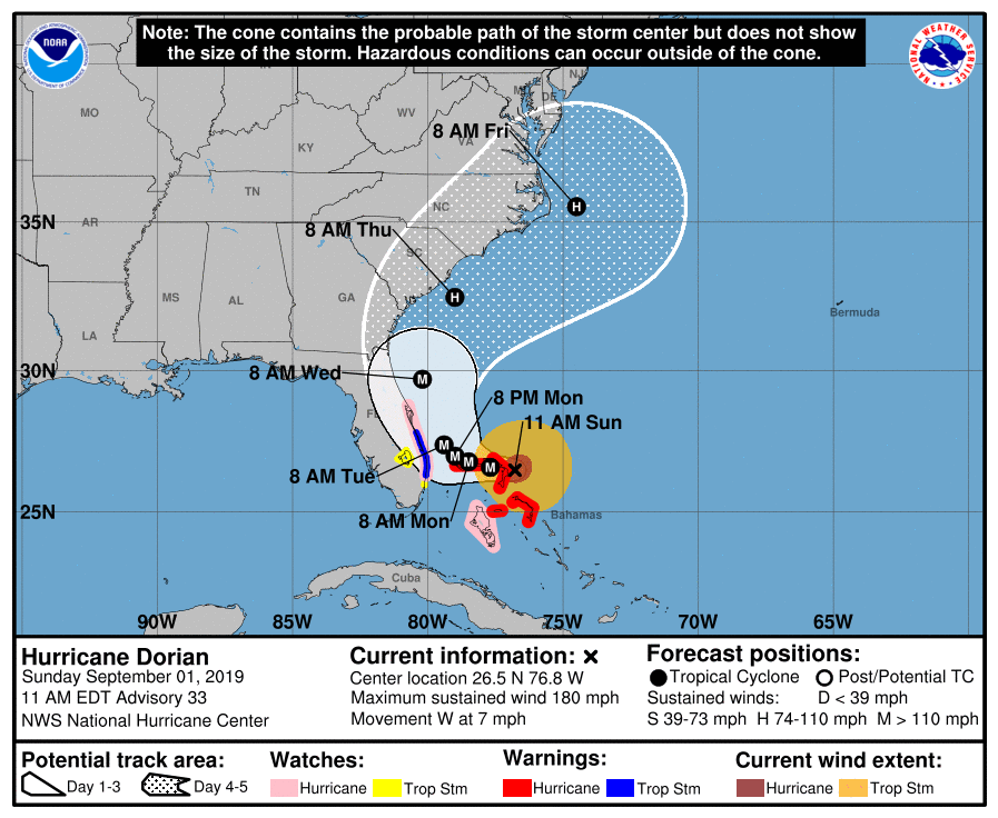
Hurricane Dorian is now a catastrophic category 5 hurricane.
As of 11 a.m. EDT Sunday, Dorian was located about 205 miles east of West Palm Beach, Florida; 20 miles east of Great Abaco Island in the Bahamas; packing winds of 180 mph with higher gusts and was moving west at 7 mph.
The hurricane has made the westward turn the National Hurricane Center had been predicting, but the NHC says a second turn to the north may still occur before reaching the East coast of Florida.
At this time there are NO weather alerts for Marion County.
Article continued below
School closings:
The Marion County School Board announced that ALL schools will be closed on Tuesday.
In a press release, officials wrote, “This closure allows time for our students, families, and employees to better prepare for the storm *AND* provides set-up time for the schools that may serve as shelters.”
Twelve-month employees should report to work as usual unless safety concerns keep them at home. In these cases, employees can request time off from their immediate supervisor.
Man on the left fills a bucket with gas. Man on the right appears to fill tote, but it’s uncertain if there is a gas can inside the tote.
As a result of Hurricane Dorian, there has been an influx of people buying large quantities of gasoline.
Unfortunately, officials say many of these people are not doing so in a safe manner.
Florida Department of Transportation officials is aware of photos circulating social media that appear to show individuals filling up non-approved fuel containers.
Officials say that not only is this illegal, but it is completely unsafe and a tragedy waiting to happen.
It falls in the category of “not very bright idea” or “hold my beer.”
Officials say you should only used approved gas containers as the fuel can melt other plastics.
Tallahassee, Fla. – To assist families as they prepare for Hurricane Dorian, the Florida Department of Children and Families (DCF) has been approved by the United States Department of Agriculture (USDA) to release September food assistance benefits to all 67 counties included in Governor Ron DeSantis’ Executive Order 19-190 declaring a State of Emergency.
Supplemental Nutrition Assistance Program (SNAP) customers who were scheduled to receive their benefits between September 1 and September 14 will now be able to access benefits through their Electronic Benefit Transfer (EBT) cards starting August 31 at noon. This is an early release of regular benefits, not a distribution of additional funds.
“I applaud Governor DeSantis and President Trump for their swift action in response to the needs of Florida’s vulnerable children and families preparing for this major hurricane,” said DCF Secretary Chad Poppell. “The early release of benefits will allow families to purchase much-needed food prior to Hurricane Dorian’s landfall.”
Immediately following Executive Order 19-190, DCF requested a waiver from the USDA allowing the early release of September SNAP benefits. With the full support of Governor DeSantis and President Donald Trump, the waiver was approved in less than 24 hours.
NOTE: You will not receive funds twice. If you run out before your actual disbursement date, then you are out until the following month.
In this video, our partners at AccuWeather shared how the NOAA helps determine the path and strength of a hurricane.
Hurricane Dorian is wide and slow-moving.
Mother nature is unpredictable, and with the path of the hurricane changing by the minute, there is a huge cone of uncertainty, the NOAA said. Even though the storm has shifted east, hurricane and tropical force winds are still a concern for Central Florida at this time. Additionally, in many areas, flooding is a concern.
The NHC says there is a possibility that if the hurricane continues to move as slow as it is while building strength, it could reach a category 5.
The NOAA urges that Floridians, particularly those along the coast, do not let their guard down.
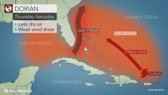
Hurricane Dorian is a powerhouse Category 4 hurricane that is a prolonged danger for parts of the Bahamas, Florida, Georgia, and the Carolinas well into next week.
Dorian’s center is about 280 miles east of the northwestern Bahamas. The hurricane is moving toward the west at 10 to 15 mph.
A hurricane warning is in effect for much of the northwestern Bahamas, including Freeport, Grand Bahama, and Nassau, New Providence Island. Andros Islands is in a hurricane watch.
Friday night, an NOAA Hurricane Hunter mission found Dorian had strengthened to a Category 4 hurricane. Dorian showed signs of “rapid intensification”, increasing from a Category 2 to Category 4 hurricane from Friday morning through Saturday morning.
A Saturday morning mission found that Dorin’s central pressure had dropped to 944 millibars, a 28 millibar drop in just 24 hours. Intense lightning was observed in the intense convection of the northern eyewall, which is a sign of the hurricane’s intensity.
Dorian does continue to shift away from the center of Florida, however, the bands are still riding along the coast at this time.
[Update brought to you by our weather partners at AccuWeather]
Dorian slowly grew in size, becoming a Category 2 storm late Thursday over the warm waters of the Atlantic.
The Bahamas and U.S. continue to prepare ahead of the storm’s expected landfall as a major hurricane.
The National Hurricane Center said during its 8 a.m. Friday advisory that Dorian’s maximum sustained winds increased to 110 mph. Dorian, located about 255 miles east-northeast of the southeastern Bahamas, was moving northwest at 12 mph early Friday morning. A hurricane watch has been issued for the northwestern Bahamas.
Dorian is expected to reach Category 4 hurricane strength before approaching the southeastern United States coast.
A major hurricane has the strength of a Category 3 or greater. A Category 4 hurricane has maximum sustained winds of at least 130 mph.
“The strengthening to a major hurricane is projected to occur while Dorian makes a more westward turn toward the northern Bahamas this weekend,” according to AccuWeather Senior Meteorologist Alex Sosnowski.
“With Dorian forecast to pass over the extremely warm water of the Gulf Stream, where cooled, upwelled water is rapidly replaced by more warm water, you have to be concerned that a Category 5 storm is on the table before reaching the U.S. coast,” Sosnowski said.
A Category 5 hurricane has maximum sustained winds of at least 157 mph.
Florida Gov. DeSantis reiterated on Friday morning that all 67 counties in Florida are under a state of emergency. He said the reason he declared a state of emergency for all 67 counties is simply because the precise path of the storm is uncertain.
“I think there is a pretty high degree of certainty this is going to be a major hurricane. Category 4, potentially category 4 plus,” DeSantis said.
He also stressed that if an area is ordered to evacuate that residents should head those warnings and evacuate.
Remember, you are your own first line when keeping yourself safe.
DeSantis said that, in the case of evacuation, the Florida Department of Transportation has already cleared the shoulders of I-95 and I-75. They have been swept, cleared, and the shoulders will be opened to traffic once evacuation orders are handed down.
Additionally, service and truck weights for fuel tankers have been waived. Beginning Friday, tankers will also be given police escorts, provided by the Florida Highway Patrol, to ensure trucks are able to refill gas stations.
DeSantis also said that nursing homes and assisted living facilities, in every county, will be spot-checked to ensure the safety of the elderly in case of a power outage. If you would like to see if the facility your loved one is in has a generator, you can visit fl/generator.com.
Marion County
On Friday, sandbag location opened in Marion County. However, unlike surrounding counties, Marion County has yet to determine what facilities will be opened as shelters. You can click here for a list of schools typically used as shelters. List provided by the Marion County Shcool Board.
Sandbag locations — Open 7 a.m. to 7 p.m.
Wrigley Field – 405 County Road E 316, Citra FL
Belleview Sports Complex – 6501 SE 107th Street, Belleview, FL
Dunnellon City Complex – 11924 Bostick Street, Dunnellon FL
East Marion Sports Complex – 14445 NE 14th Street Road, Silver Springs FL
City of Ocala
Reilly Arts Center – 500 NE 9th Street, Ocala FL
ED Crosky Recreation Center – 1510 NW Fourth Street, Ocala, FL
Ocala Post continues to work closely with the Governor’s office, the NOAA, The National Hurricane Center, and AccuWeather to bring you the most accurate and up-to-date information. Stay tuned for more updates.
[Update brought to you by our weather partners at AccuWeather]
Overnight, as Hurricane Dorian moved into the warmer, open waters, greater concern grew about the storm’s projected path towards Florida.
The concern is that Dorian could strike as a major hurricane over the upcoming holiday weekend.
The National Hurricane Center said during its noon advisory that the storm was about 220 miles north-northwest of San Juan and 370 miles east-southeast of the Bahamas. The storm, still packing maximum sustained winds of 85 mph, was moving at 13 mph as it entered the open — and warmer — waters of the southern Atlantic.
As Dorian tracks north, it is expected to reach Category 4 hurricane strength before approaching the southeastern United States coast.
A Category 4 hurricane has maximum sustained winds of at least 130 mph.
“The strengthening to a major hurricane is projected to occur while making a more westward turn toward the northern Bahamas this weekend,” According to AccuWeather Senior Meteorologist Alex Sosnowski.
“Dorian is forecasted to pass over the extremely warm water of the Gulf Stream, where the water is rapidly replaced by more warm water, you have to be concerned that a Category 5 storm is on the table before reaching the U.S. coast,” Sosnowski said.
A Category 5 hurricane has maximum sustained winds of at least 157 mph.
The NOAA has stressed that this model is not set in stone and that, a greater turn to the north is still possible at this point.
“The hurricane could still turn to the north and bypass Florida completely,” the NOAA said. “However, we are still urging everyone along the coast of Florida and the Carolinas to be prepared.”
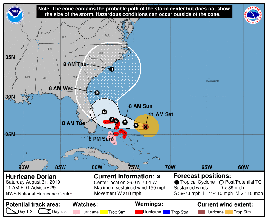
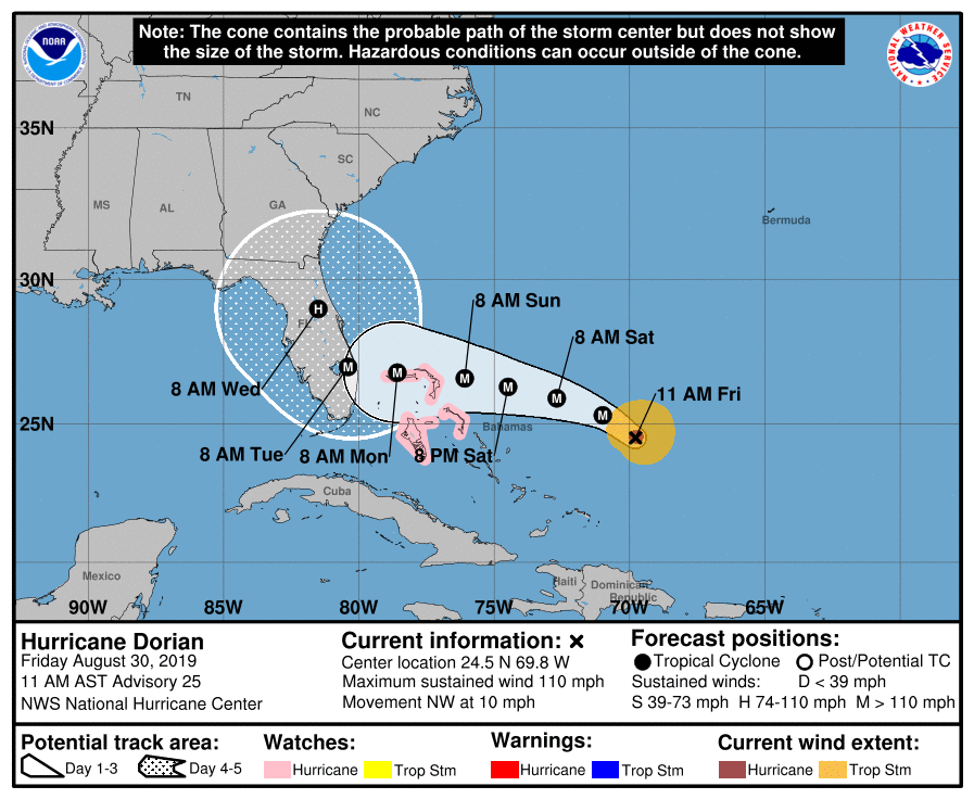
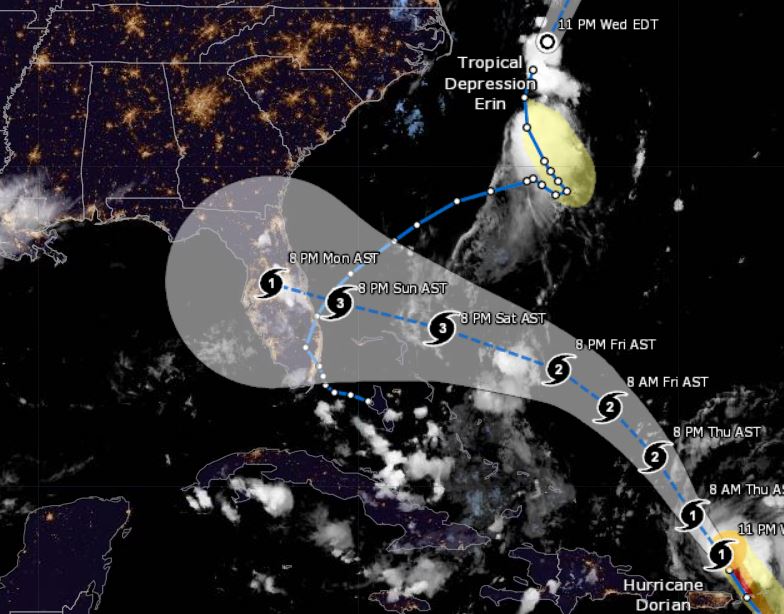
Graphic-The letter inside the dot indicates the NHC’s forecast intensity for that time:
D: Tropical Depression – wind speed less than 39 MPH
S: Tropical Storm – wind speed between 39 MPH and 73 MPH
H: Hurricane – wind speed between 74 MPH and 110 MPH
M: Major Hurricane – wind speed greater than 110 MPH
[Hurricane Dorian update brought to you by our weather partners at AccuWeather]
Wednesday night, Hurricane Dorian pulled away from Puerto Rico and the Virgin Islands.
Dorian, continuing to gather strength, increased winds to 85 mph.
In a press release, The National Hurricane Center said the storm was about 90 miles north of San Juan and moving northwest at 13 mph as it headed for the open — and warmer — waters of the southern Atlantic.
As Dorian heads north of the Bahamas, possibly later this week, it is expected to reach Category 3 hurricane.
During a press conference On Wednesday, Florida Gov. Ron DeSantis declared a state of emergency to give officials enough time to prepare for the storm and urged all Floridians on the state’s east coast to “have 7 days of supplies, prepare their homes and follow the track closely.”
The storm made a shift to the north on Wednesday, causing its center to regenerate northeast of Puerto Rico. Therefore, this made the development of the Atlantic’s first major hurricane of the 2019 season very likely.
The hurricane brought heavy rain to Puerto Rico and parts of the U.S. and British Virgin Islands on Wednesday after it battered portions of the Lesser Antilles.
On Wednesday evening, lightning was detected in the eye of Dorian.
According to the NOAA, when lightning is detected in the eye of a hurricane, it is usually an indication of rapid strengthening.
The NOAA said moving into the warm waters of the southern Atlantic will provide the right conditions for Dorian to continue strengthening.
Meteorologists are forecasting that Dorian will be a major hurricane before making landfall as a Category 3 because water temperatures in Dorian’s path range from 84-86 degrees Fahrenheit..the perfect fuel for a hurricane.