The following are important changes in weather watches and warnings. This information comes directly from the National Weather Service (NWS).
Dorian has weakened slightly but remains a very dangerous category 4 hurricane.
If you have family or friends in any of the areas who do not have access to the news, you should alert them.
Don’t panic, not all of the information pertains to Marion County. However, many readers have elderly family members in the listed areas, and at the request of our readers, the decision was made to include that information.
Changes to watches and warning:
– A Storm Surge Watch and Hurricane Watch have been issued for Coastal Camden and Coastal Glynn
– A Storm Surge Watch has been issued for Inland Glynn- A Storm Surge Watch and Hurricane Watch are in effect for Coastal Camden, Coastal Duval, Coastal Flagler, Coastal Glynn,
Coastal Nassau, and Coastal St. Johns
– A Hurricane Watch is in effect for Inland Flagler and Inland St. Johns
– A Storm Surge Watch is in effect for Inland Glynn
– A Tropical Storm Watch is in effect for Clay, Eastern Marion,
Inland Duval, Inland Nassau, and Putnam
Storm information:
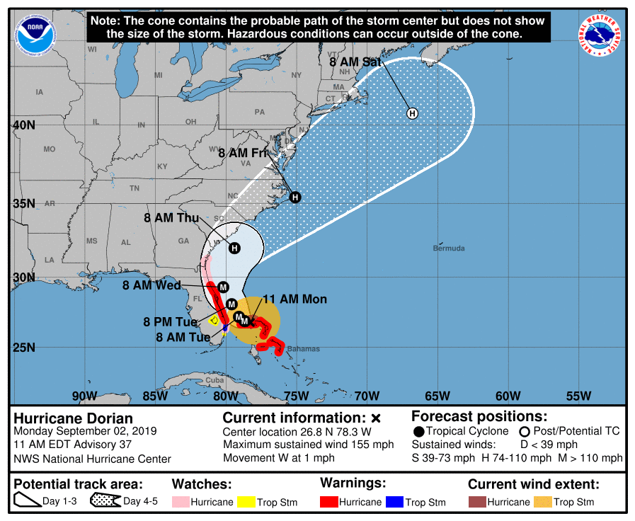
– About 310 miles southeast of Jacksonville FL
– 26.8N 78.3W
– Storm Intensity 155 mph
– Movement West or 280 degrees at 1 mph
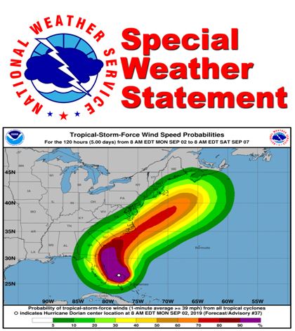
Hurricane Dorian is a powerful and extremely dangerous Category 4 hurricane with peak winds near 155 mph.
Dorian`s forward progress has slowed as it continues to move west through the northwestern Bahamas.
By Tuesday, powerful Dorian is forecast to turn northwest on its way towards the Florida coast. As Dorian slowly approaches, it is forecast to turn north-northwest and parallel the coastline Tuesday into Wednesday.
“At this time, the exact track remains uncertain, and small changes in the forecast, the track could have large influences on the threat of damaging winds and life-threatening storm surge,” NWS said in a statement.
Regardless, as the storm slowly draws closer, the risk has increased with the latest forecast. Should Dorian approach even closer, it would produce more serious impacts to coastal areas.
Large battering waves and higher than normal tides will add to the destructive potential, along with beach erosion.
Heavy rainfall is forecast over eastern parts of northeast Florida and coastal southeast Georgia and with total accumulations of 4 to 8 inches…with maximum isolated rainfall amounts to 10 inches along
the east coast. Flash flooding is possible, especially in urban and poorly drained areas.
Potential impacts
Surges:
Prepare for life-threatening surge having possible extensive impacts across the beaches of coastal northeast Florida and southeast Georgia. As well as the mouth of the St Johns River. Potential impacts in this area include:
– Large areas of deep inundation with storm surge flooding accentuated by battering waves. Structural damage to buildings, with several washing away. Damage compounded by floating debris. Locations may be uninhabitable for an extended period.
– Large sections of near-shore escape routes and secondary roads washed out or severely flooded. Flood control systems and barriers may become stressed.
– Severe beach erosion with significant dune loss.
– Major damage to marinas, docks, boardwalks, and piers. Many small craft has broken away from moorings, especially in unprotected anchorages with some lifted onshore and stranded.
Wind:
Prepare for life-threatening wind having possible extensive impacts across coastal sections of northeast Florida and southeast Georgia.
Potential impacts in this area include:
– Considerable roof damage to sturdy buildings, with some having window, door, and garage door failures leading to structural damage. Mobile homes severely damaged, with some destroyed. Damage accentuated by airborne projectiles. Locations may be uninhabitable for weeks.
– Many large trees snapped or uprooted along with fences and roadway signs blown over.
– Some roads impassable from large debris, and more within urban or heavily wooded places. Several bridges, causeways, and access routes impassable.
– Large areas with power and communications outages.
Also, prepare for dangerous wind having possible limited to significant impacts across inland Nassau, inland Duval, Clay, Putnam, and eastern Marion Counties.
Flooding:
Prepare for dangerous rainfall flooding having possible significant impacts across coastal northeast Florida and southeast Georgia.
Potential impacts include:
– Moderate rainfall flooding may prompt several evacuations and rescues.
– Rivers and tributaries may quickly become swollen with swifter currents and overspill their banks in a few places, especially in usually vulnerable spots. Small streams, creeks, canals, and ditches overflow.
– Floodwaters can enter some structures or weaken foundations. Several places may experience expanded areas of rapid inundation at underpasses, low-lying spots, and poor drainage areas. Some streets and parking lots take on moving water as storm drains and retention ponds overflow. Driving conditions become hazardous. Some road and bridge closures.
Preparedness
Evacuations:
Listen to local official for recommended preparedness actions, including possible evacuation. If ordered to evacuate, do so immediately.
For those not under evacuation orders, assess the risk from wind, falling trees, and flooding at your location. If you decide to move, relocate to a safer location nearby. If you do not relocate, help keep
roadways open for those under evacuation orders. If evacuating, leave with a destination in mind and allow extra time to get there. Take your emergency supplies kit. Gas up your vehicle ahead of time.
Let others know where you are going prior to departure.
Secure loose items and pets in the car, and avoid distracted driving.
If evacuating, follow designated evacuation routes. Seek traffic information on roadway signs, the radio, and from official sources.
Now is the time to check your emergency plan and emergency supplies kit and take necessary actions to protect your family and secure your home or business.
When making safety and preparedness decisions, do not focus on the exact forecast track since hazards such as flooding rain, damaging wind gusts, storm surge, and tornadoes extend well away from the
center of the storm.
If in a place that is vulnerable to high wind, such as near large trees, a manufactured home, upper floors of a high-rise building, or on a boat, plan to move to safe shelter. If you live in a place particularly vulnerable to flooding, such as near the ocean or a large inland lake, in a low-lying or poor
drainage area, in a valley, or near an already swollen river, plan to move to safe shelter on higher ground.
Always heed the advice of local officials and comply with orders that are issued. Do not needlessly jeopardize your life or the lives of others.
When securing your property, outside preparations should be concluded as soon as possible before conditions deteriorate. The onset of strong gusty winds or flooding can cause certain preparedness
activities to become unsafe.
Be sure to let friends and family members know of your intentions for weathering the storm and your whereabouts. Have someone located away from the threatened area serve as your point of contact. Share vital contact information with others. Keep cell phones handy and charged.
Check on those who may not be fully aware of the situation or who are unable to make personal preparations.
The next local statement will be issued by the National Weather Service in Jacksonville FL around 6 PM, or sooner if conditions warrant.