[Update brought to you by our weather partners at AccuWeather]
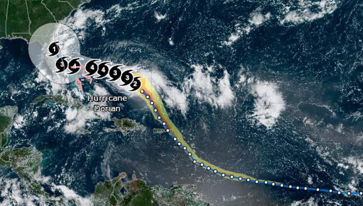
Dorian slowly grew in size, becoming a Category 2 storm late Thursday over the warm waters of the Atlantic.
The Bahamas and U.S. continue to prepare ahead of the storm’s expected landfall as a major hurricane.
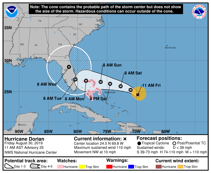
The National Hurricane Center said during its 8 a.m. Friday advisory that Dorian’s maximum sustained winds increased to 110 mph. Dorian, located about 255 miles east-northeast of the southeastern Bahamas, was moving northwest at 12 mph early Friday morning. A hurricane watch has been issued for the northwestern Bahamas.
Dorian is expected to reach Category 4 hurricane strength before approaching the southeastern United States coast.
A major hurricane has the strength of a Category 3 or greater. A Category 4 hurricane has maximum sustained winds of at least 130 mph.
“The strengthening to a major hurricane is projected to occur while Dorian makes a more westward turn toward the northern Bahamas this weekend,” according to AccuWeather Senior Meteorologist Alex Sosnowski.
“With Dorian forecast to pass over the extremely warm water of the Gulf Stream, where cooled, upwelled water is rapidly replaced by more warm water, you have to be concerned that a Category 5 storm is on the table before reaching the U.S. coast,” Sosnowski said.
A Category 5 hurricane has maximum sustained winds of at least 157 mph.
Florida Gov. DeSantis reiterated on Friday morning that all 67 counties in Florida are under a state of emergency. He said the reason he declared a state of emergency for all 67 counties is simply because the precise path of the storm is uncertain.
“I think there is a pretty high degree of certainty this is going to be a major hurricane. Category 4, potentially category 4 plus,” DeSantis said.
He also stressed that if an area is ordered to evacuate that residents should head those warnings and evacuate.
Remember, you are your own first line when keeping yourself safe.
DeSantis said that, in the case of evacuation, the Florida Department of Transportation has already cleared the shoulders of I-95 and I-75. They have been swept, cleared, and the shoulders will be opened to traffic once evacuation orders are handed down.
Additionally, service and truck weights for fuel tankers have been waived. Beginning Friday, tankers will also be given police escorts, provided by the Florida Highway Patrol, to ensure trucks are able to refill gas stations.
DeSantis also said that nursing homes and assisted living facilities, in every county, will be spot-checked to ensure the safety of the elderly in case of a power outage. If you would like to see if the facility your loved one is in has a generator, you can visit fl/generator.com.
Marion County
On Friday, sandbag location opened in Marion County. However, unlike surrounding counties, Marion County has yet to determine what facilities will be opened as shelters. You can click here for a list of schools typically used as shelters. List provided by the Marion County Shcool Board.
Sandbag locations — Open 7 a.m. to 7 p.m.
- Wrigley Field – 405 County Road E 316, Citra FL
- Belleview Sports Complex – 6501 SE 107th Street, Belleview, FL
- Dunnellon City Complex – 11924 Bostick Street, Dunnellon FL
- East Marion Sports Complex – 14445 NE 14th Street Road, Silver Springs FL
City of Ocala
- Reilly Arts Center – 500 NE 9th Street, Ocala FL
- ED Crosky Recreation Center – 1510 NW Fourth Street, Ocala, FL
Ocala Post continues to work closely with the Governor’s office, the NOAA, The National Hurricane Center, and AccuWeather to bring you the most accurate and up-to-date information. Stay tuned for more updates.