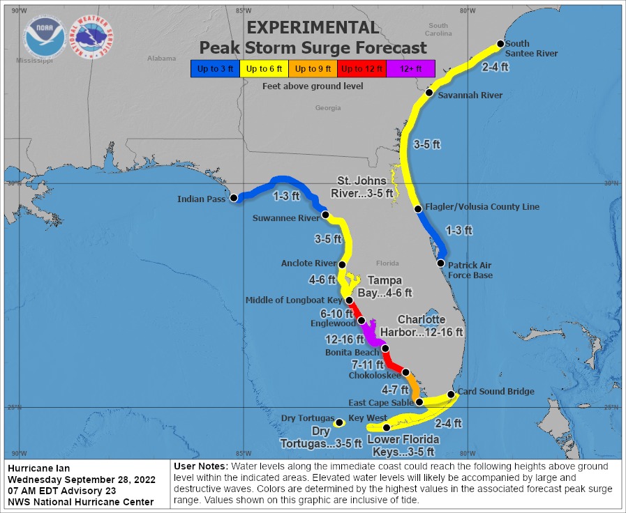
IAN IS EXPECTED TO CAUSE CATASTROPHIC STORM SURGE, WINDS, AND FLOODING IN THE FLORIDA PENINSULA STARTING LATER TODAY…
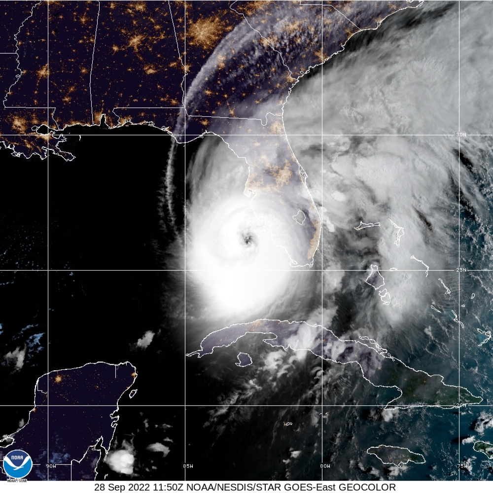
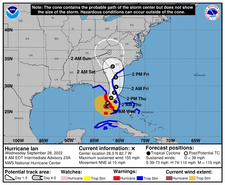
At 8:00 AM, the eye of Hurricane Ian was located by Air Force and NOAA Hurricane Hunter data plus Key West radar about 55 miles (90 km) west of Naples, Florida.
Ian is moving toward the north-northeast near 10 mph (17 km/h). This general motion with a reduction in forwarding speed is forecast today, followed by a turn toward the north on Thursday.
On the forecast track, the center of Ian is expected to move onshore within the hurricane warning area later this morning or early afternoon.
The center of Ian is forecast to move over central Florida tonight and Thursday morning and emerge over the western Atlantic by late Thursday.
Maximum sustained winds remain near 155 mph (250 km/h) with higher gusts.
Ian is a category 4 hurricane on the Saffir-Simpson Hurricane Wind Scale.
Article continued below
Ian is forecast to make landfall on the west coast of Florida as a catastrophic hurricane.
Weakening is expected after landfall, however, hurricane-force winds extend outward up to 40 miles (65 km) from the center and tropical-storm-force winds extend outward up to 175 miles (280 km). The minimum central pressure is 937 MB (27.67 inches) based on Air Force Hurricane Hunter dropsonde data.
Article continued below
WIND: Catastrophic wind damage is likely where the core of Ian moves onshore. Hurricane conditions will begin along the west coast of Florida within the Hurricane Warning area later this morning, with tropical storm conditions beginning before daybreak.
Tropical storm conditions are occurring in the warning area in the Florida Keys, and will continue this morning. Tropical storm conditions are expected in the warning area on the east coast of Florida beginning today and should spread up the Georgia and South Carolina coasts tonight and Thursday. Tropical storm conditions are expected within the warning area in Cuba for the next few hours.
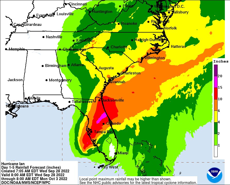
RAINFALL: Ian is expected to produce the following storm total rainfall:
* Florida Keys and South Florida: 6 to 8 inches, with local maxima up to 12 inches.
* Central and Northeast Florida: 12 to 18 inches, with local maxima up to 24 inches.
* Eastern Georgia and Coastal South Carolina: 4 to 8 inches, with local maxima of 12 inches.
SURF: Swells generated by Ian are affecting the northern coast of Cuba, the northeastern coast of the Yucatan peninsula, and the west coast of Florida. Swells will increase along the east coast of Florida, Georgia, and South Carolina tonight and Thursday. These swells are likely to cause life-threatening surf and rip current conditions.
TORNADOES: Tornadoes are possible today and tonight across central and south Florida.
SURF: Swells generated by Ian are affecting the northern coast of Cuba, the northeastern coast of the Yucatan peninsula, and the west coast of Florida. Swells will increase along the east coast of Florida, Georgia, and South Carolina tonight and Thursday. These swells are likely to cause life-threatening surf and rip current conditions.
D: Tropical Depression – wind speed less than 39 MPH
S: Tropical Storm – wind speed between 39 MPH and 73 MPH
H: Hurricane – wind speed between 74 MPH and 110 MPH
M: Major Hurricane – wind speed greater than 110 MPH