
[Last updated on September 1, 2016, at 4:00 p.m. Video is brought to you by our partners at AccuWeather. Alerts will be updated throughout the day.]
Hermine has strengthened to a hurricane and will deliver heavy rain, gusty winds, flooding and possibly tornadoes into Friday.
This will be the first hurricane to make landfall in Florida since 2005, when Wilma hit.
The center of Hermine has made the anticipated northeastward turn and is located about 135 miles south of Apalachicola, Florida, and 180 miles southwest of Cedar Key, Florida.
Marion County is under a Tropical Storm watch for the next 36 hours. A tornado warning is in effect until 11 p.m. Residents can expect winds between 35-48 mph with gusts up to 60 mph. Flooding is also possible. These conditions can be expected to continue into Friday.
Thursday night, tropical storm conditions expected with the possibility of rain and thunderstorms. Some of the storms could produce heavy rain. Low around 75. South wind 22 to 27 mph increasing to 31 to 41 mph. Winds could gust as high as 60 mph. Chance of precipitation is 90%.
Friday morning, rain with the possibly of thunderstorms. Some of the storms could produce heavy rain. High near 83. Very windy, with a southwest wind 22 to 25 mph, with gusts as high as 38 mph. Chance of precipitation is 80%.
Friday night, rain and thunderstorms likely. Some of the storms could produce heavy rain. Cloudy, with a low around 75. Southwest wind 7 to 10 mph. Chance of precipitation is 60%.
Marion County remains under a Tropical Storm Warning as well as a Tornado and Flood Watch.
These threats should diminish by Saturday.
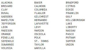
The following counties are also under a Tornado Watch.
Article continued below

Schools closed as of now
On Thursday, officials announced that all Marion County Public Schools will be closed
Citrus County officials announced schools will be closed in that area.
Dixie County Schools are closed on Thursday and Friday. A shelter will open at Old Town Elementary School at 8:00 a.m. on Thursday.
Leon, Wakulla, Gadsden, Franklin, and Taylor County Public Schools are closed Thursday and Friday.
Gilchrist County Schools are closed on Thursday and Friday. School events scheduled for Thursday will also be cancelled, those on Friday are pending decision.
Hernando County Schools are closed Thursday. They have not decided on Friday.
Lafayette County Schools are closed on Thursday and Friday.
Levy County Schools are closed Thursday.
Hillsborough County public schools are closed on Thursday. No decision on Friday.
Manatee County District Schools and School District offices will be closed Thursday. No decision has been made for Friday.
***
“We expect the storm to become a hurricane before making landfall north of Tampa and perhaps close to Apalachicola, in the Big Bend of Florida during Thursday evening,” according to AccuWeather Hurricane Expert Dan Kottlowski.
According to AccuWeather, people in the central and northern part of the Florida Peninsula and the eastern part of the Florida Panhandle should be prepared for hurricane conditions with power outages, flooded roads, and airline disruptions.
On Wednesday, a hurricane watch was issued for the Florida Gulf Coast from the Anclote River Indian Pass. A tropical storm watch has been issued for the Florida Gulf Coast west of Indian Pass to the Walton/Bay County line.
Some airlines have announced that they are waving flight change fees in the path of the storm.
Original article continued below
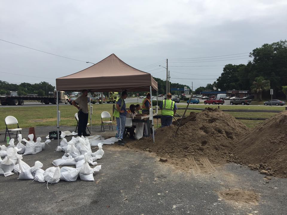
The City of Ocala will be opening sandbag locations on Tuesday, August 30, and Wednesday, August 31, from 8 a.m. to 6 p.m..
Locations:
- Corner of 8th Avenue and 14th Street, just north of Tuscawilla Park
- Corner of State Road 40 and Martin Luther King, Jr. Blvd. just east of the Hampton Center.
Additionally, Marion County Emergency Management, starting at 9 a.m., Tuesday, will distribute sandbags at four Marion County Sheriff district offices.
Locations:
- North Multi District Office – 8311 N Hwy 441, Ocala, FL 34479
- South Multi District Office – 3260 SE 80th Street, Ocala, Fl 34480
- Forest District Office – 1600 E. Hwy 40, Silver Springs, FL 34488
- Dunnellon District Office – 19995 SW 86th St. Unit 3, Dunnellon, FL 34433
Sandbags will be provided to residents at no charge. The limit is 10 per resident.
Check back for frequent updates.