
Florida residents! If the driving rain and wind isn’t enough to convince you to remain sheltered in place, there is also the very real threat of tornadoes, even in the outer bands of #Milton.
These tornadoes spin up quickly and move quickly – making staying in a safe place the best possible option.
___
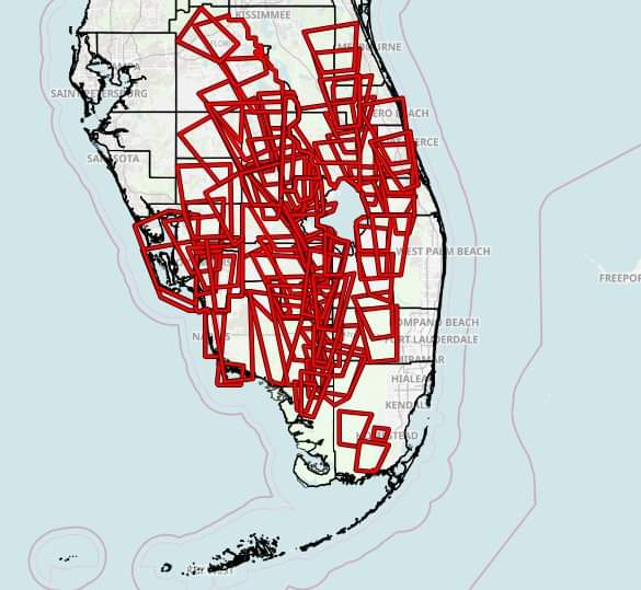
Here is a view of all of the *Tornado Warnings* issued by US National Weather Service thus far.
More than 50 total tornado warnings have been issued so far.
As of 11 p.m it was estimated that 1.2 million Floridians were without power.
Additionally, due to wind speeds, emergency services have been suspended for several counties.
WEATHER STATEMENT
Milton Local Watch/Warning Statement/Advisory Number 20
National Weather Service Jacksonville FL  AL142024
1054 PM EDT Wed Oct 9 2024

FLZ340-101100-
/O.CON.KJAX.HU.W.1014.000000T0000Z-000000T0000Z/
Western Marion-
1054 PM EDT Wed Oct 9 2024

...HURRICANE WARNING REMAINS IN EFFECT...

* LOCATIONS AFFECTED
    - Ocala Airport
    - Rainbow Lakes Estates
    - Dunnellon
    - Romeo

* WIND
    - LATEST LOCAL FORECAST: Below tropical storm force wind
        - Peak Wind Forecast: 25-35 mph with gusts to 60 mph

    - THREAT TO LIFE AND PROPERTY THAT INCLUDES TYPICAL FORECAST
      UNCERTAINTY IN TRACK, SIZE AND INTENSITY: Potential for wind 58
      to 73 mph
        - The wind threat has remained nearly steady from the
          previous assessment.
        - PLAN: Plan for dangerous wind of equivalent strong tropical
          storm force.
        - PREPARE: Remaining efforts to protect life and property
          should be completed as soon as possible. Prepare for
          significant wind damage.
        - ACT: Move to safe shelter before the wind becomes hazardous.

    - POTENTIAL IMPACTS: Significant
        - Some damage to roofing and siding materials, along with
          damage to porches, awnings, carports, and sheds. A few
          buildings experiencing window, door, and garage door
          failures. Mobile homes damaged, especially if unanchored.
          Unsecured lightweight objects become dangerous projectiles.
        - Several large trees snapped or uprooted, but with greater
          numbers in places where trees are shallow rooted. Several
          fences and roadway signs blown over.
        - Some roads impassable from large debris, and more within
          urban or heavily wooded places. A few bridges, causeways,
          and access routes impassable.
        - Scattered power and communications outages, but more
          prevalent in areas with above ground lines.

* FLOODING RAIN
    - LATEST LOCAL FORECAST: Flood Watch is in effect
        - Peak Rainfall Amounts: Additional 1-3 inches, with locally
          higher amounts

    - THREAT TO LIFE AND PROPERTY THAT INCLUDES TYPICAL FORECAST
      UNCERTAINTY IN TRACK, SIZE AND INTENSITY: Potential for major
      flooding rain
        - The flooding rain threat has remained nearly steady from
          the previous assessment.
        - PLAN: Emergency plans should include the potential for
          major flooding from heavy rain. Evacuations and rescues are
          likely.
        - PREPARE: Strongly consider protective actions, especially
          if you are in an area vulnerable to flooding.
        - ACT: Heed any flood watches and warnings. Failure to take
          action will likely result in serious injury or loss of life.

    - POTENTIAL IMPACTS: Extensive
        - Major rainfall flooding may prompt many evacuations and
          rescues.
        - Rivers and tributaries may rapidly overflow their banks in
          multiple places. Small streams, creeks, canals, and ditches
          may become dangerous rivers. Flood control systems and
          barriers may become stressed.
        - Flood waters can enter many structures within multiple
          communities, some structures becoming uninhabitable or
          washed away. Many places where flood waters may cover
          escape routes. Streets and parking lots become rivers of
          moving water with underpasses submerged. Driving conditions
          become dangerous. Many road and bridge closures with some
          weakened or washed out.

* TORNADO
    - LATEST LOCAL FORECAST:
        - Situation is unfavorable for tornadoes

    - THREAT TO LIFE AND PROPERTY THAT INCLUDES TYPICAL FORECAST
      UNCERTAINTY IN TRACK, SIZE AND INTENSITY: Tornadoes not expected
        - The tornado threat has decreased from the previous
          assessment.
        - PLAN: Tornadoes are not expected. Showers and thunderstorms
          with gusty winds may still occur.
        - PREPARE: Little to no preparations needed to protect
          against tornadoes at this time. Keep informed of the latest
          tornado situation.
        - ACT: Listen for changes in the forecast.

    - POTENTIAL IMPACTS: Little to None
        - Little to no potential impacts from tornadoes.

* FOR MORE INFORMATION:
    - Family Emergency Plans (FEMA): http://ready.gov/hurricanes
    - Local weather conditions and forecasts: http://www.weather.gov/jax/
Stay tuned to your local weather for new developments and sudden changes.
Follow and like us: