IAN is BATTERING THE FLORIDA PENINSULA WITH CATASTROPHIC STORM SURGE, WINDS, AND FLOODING…
…NEW WATCHES AND WARNINGS WERE ISSUED FOR NORTH AND SOUTH CAROLINA.
A tropical storm warning remains in effect for Marion County. A Flood watch is also in effect until October 1.
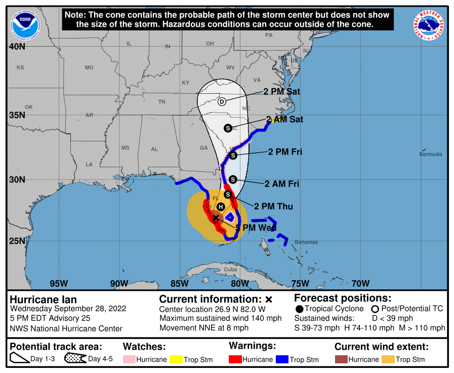
At 500 PM EDT, the eye of Hurricane Ian was located about 5 miles east of Punta Gorda, Florida.
Ian is moving toward the north-northeast near 8 mph (13 km/h).
On the forecast track, the center of Ian is expected to move across central Florida tonight and Thursday morning and emerge over the western Atlantic by late Thursday.
Ian is forecast to turn northward on Friday and approach the northeastern Florida coast, Georgia, and South Carolina coasts late Friday.
Maximum sustained winds have decreased to near 140 mph (220 km/h) with higher gusts. Ian is a category 4 hurricane on the Saffir-Simpson Hurricane Wind Scale.
Further weakening is expected for the next day or so, but Ian could be near hurricane strength when it moves over the Florida East coast tomorrow, and when it approaches the northeastern Florida, Georgia, and South Carolina coasts late Friday.
Hurricane-force winds extend outward up to 50 miles (85 km) from the center and tropical-storm-force winds extend outward up to 175 miles (280 km).
A WeatherFlow station in Grove City recently reported sustained winds of 95 mph (153 km/h) and a wind gust of 128 mph (208 km/h).
A University of Florida Coastal Monitoring Program wind tower recently reported sustained winds of 89 mph (143 km/h) with a gust to 114 mph (183 km/h).
The estimated minimum central pressure is 945 mb (27.91 inches).
Marion County Detailed Forecast
Tonight
Tropical storm conditions are expected. Showers and possibly a thunderstorm. Some of the storms could produce heavy rainfall. Low around 70. The chance of precipitation is 90%. New rainfall amounts between 3 and 4 inches are possible.
Thursday
Tropical storm conditions are expected. Showers and possibly a thunderstorm. Some of the storms could produce heavy rainfall. High near 75. The chance of precipitation is 90%. New rainfall amounts between 3 and 4 inches are possible.
Thursday Night
Showers, mainly before 3am. The rain could be heavy at times. Low around 66. Very windy, with a northwest wind 18 to 25 mph, with gusts as high as 40 mph. The chance of precipitation is 80%. New precipitation amounts between 1 and 2 inches are possible.
Friday
A 40 percent chance of showers. Cloudy, with a high near 76. Breezy, with a northwest wind 14 to 16 mph.
Friday Night
A 40 percent chance of showers, mainly before 9pm. Mostly cloudy, with a low of around 63. Northwest wind 5 to 9 mph becoming light west after midnight.